5214 Burleson Road#Suite 411, Austin, TX 78744
Commercial property record · Travis County · Commercial improved · Austin commercial real estate
Public record for 5214 Burleson Road in Austin, TX: who owns it, what the county assesses it at, land use and lot size, plus flood zone, natural hazard risk and EPA records. Free, no account needed.
On the market here
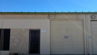
At a glance
Public data gathered Nov 6, 2026.
Flood
Outside FEMA's 100-year floodplain No concern on record.
Flood zone X
Natural hazards
Tornado and hail rated high Worth a closer look.
Low risk overall
Environmental
178 EPA-tracked facilities within a mile Worth a closer look.
No severe violators; no open leaking-tank cases within half a mile
People nearby
3,784 people within a mile
Median household income $69,179
Getting there
Highway exit: TX 71 · 0.7 mi
International airport: Austin-Bergstrom International Airport (AUS) · 3.9 mi
Property records for 5214 Burleson Road
Owner and assessed value
Researched Nov 6, 2026- Recorded Owner
- CAPITAL AUSTIN LLC1
- Assessor Land Use
- COMMERCIAL IMPROVED1
- Zoning Code
- LI-NP2
- Zoning Designation
- Limited Industrial Services-Neighborhood Plan (LI-NP) combining district3
- Assessed Value
- $17,700,0004
- Market Value
- $17,700,0004
- Annual Property Tax
- $366,423/yr4
- Tax Year
- 20254
- Last Sale Date
- Apr 1, 20191
Tax lots
1 lot| Parcel number | Acres | Assessed | Market | Annual tax |
|---|---|---|---|---|
| 03-1608-0103-00004 | 4.9174 | $17,700,000 | $17,700,000 | $366,423 |
Recorded sales
| Date | Document |
|---|---|
| Apr 1, 20191 | 2019045605 |
Sources
- 1 Parcels · taxmaps.traviscountytx.gov
- 2 maps.austintexas.gov · maps.austintexas.gov
- 3 services.austintexas.gov · services.austintexas.govDocument kept Nov 6, 2026: austin-ordinance-20051020-056.pdf · 155.9 KB
- 4 online.go2gov.net · online.go2gov.netDocument kept Nov 6, 2026: tax-bill-original-2025.pdf · 286.7 KB
Figures as the county publishes them. Each source links to the page it was read from and, where the county published a document, to a copy kept on the day it was read.
Due diligence
 Find a commercial property inspector Book a certified commercial inspector in this area.
 Investment Property Analyzer Run the numbers on this property before you offer. Free.
From our partner CCPIA — the Certified Commercial Property Inspectors Association
Flood zone, hazard risk and the area around it
Getting there
Straight-line distance- Highway exit
- TX 71 · 0.7 mi
- Freight rail
- UP Austin Subdivision · 3.1 mi
- International airport
- Austin-Bergstrom International Airport (AUS) · 3.9 mi
Within a mile: 13 restaurants · 18 shops · 6 grocery stores · 0 schools · 4 parks
Nearby brands
Nearest location · within 1 mi- Shell Fuel
- 0.3 mi
- Meson Sandwiches Food
- 0.4 mi
- Apple Store Retail
- 0.5 mi
- McDonald's Food
- 0.5 mi
- Exxon Fuel
- 0.6 mi
Distances and places from © OpenStreetMap contributors.
Demographics
U.S. Census ACS · 2019–2023 · LEHD| Statistic | 1 mi | 3 mi | 5 mi |
|---|---|---|---|
| Population | 3,784 | 105,820 | 249,147 |
| Jobs (people working here) | 6,665 | 68,428 | 301,328 |
| Daytime population (est.) | 8,201 | 120,824 | 422,678 |
| Median household income | $69,179 | $74,575 | $88,621 |
Household income
Share of households · 1 mi- Under $25k
- 14%
- 241
- $25k–$50k
- 23%
- 399
- $50k–$100k
- 35%
- 595
- $100k–$200k
- 23%
- 398
- $200k+
- 4%
- 68
Population by age
Share of residents · 1 mi- Under 18
- 21%
- 810
- 18–24
- 3%
- 98
- 25–34
- 29%
- 1,097
- 35–44
- 16%
- 595
- 45–54
- 10%
- 381
- 55–64
- 12%
- 446
- 65–74
- 5%
- 205
- 75+
- 4%
- 152
Housing
Share of housing units · 1 mi- Owner occupied
- 29%
- 545
- Renter occupied
- 62%
- 1,156
- Vacant
- 8%
- 155
Median income by age
Age of householder · 1 mi- 25–44
- $79,790
- 45–64
- $75,205
- 65+
- $42,048
Jobs by industry
Share of jobs · 1 mi- Retail, food & lodging
- 15%
- 980
- Health care
- <1%
- 23
- Education
- <1%
- 27
- Professional & finance
- 16%
- 1,088
- Construction & manufacturing
- 40%
- 2,691
- Wholesale & logistics
- 17%
- 1,156
- Government
- 0%
- 0
- Other services
- 11%
- 700
Education
Share of adults 25+ · 1 mi- No HS diploma
- 12%
- 355
- High school
- 18%
- 518
- Some college
- 28%
- 792
- Bachelor's
- 35%
- 1,003
- Graduate
- 7%
- 208
Race & ethnicity
Share of residents · 1 mi- White
- 45%
- 1,691
- Black or African American
- 5%
- 182
- Asian
- 3%
- 101
- Two or more races
- 25%
- 961
- Other
- 22%
- 849
Hispanic or Latino, of any race 49%
Natural hazard risk
FEMA National Risk Index · December 2025- Overall
- Low
- Tornado
- High
- Hail
- High
- Heat wave
- Moderate
- Flooding (inland)
- Low
- Strong wind
- Low
- Lightning
- Low
- Cold wave
- Low
- Winter weather
- Low
- Wildfire
- Very Low
- Hurricane
- Very Low
- Ice storm
- Very Low
- Drought
- Very Low
- Earthquake
- Very Low
- Landslide
- Very Low
Ratings are for the census tract, relative to all U.S. tracts — not a parcel-level model.
- EPA-Tracked Facilities Within 1 Mile
- 178
- Toxic-Release Facilities Within 1 Mile
- 1
- EPA Severe Violators Within 1 Mile
- 0
- Open Leaking-Tank Cases Within ½ Mile
- 0
- Leaking-Tank Releases Within ½ Mile
- 5
- Underground Tank Sites Within ¼ Mile
- 4
- In FEMA Special Flood Hazard Area
- No
Location & Zoning
- FEMA Flood Zone
- X
- Opportunity Zone
- No