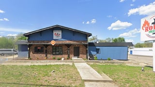
945 36th Street Southwest, Wyoming, MI 49509
Commercial property record · Kent County · Wyoming commercial real estate
Public record for 945 36th Street Southwest in Wyoming, MI: who owns it, land use and lot size, plus flood zone, natural hazard risk and EPA records. Free, no account needed.
On the market here
At a glance
Public data gathered Nov 1, 2026.
Flood
Outside FEMA's 100-year floodplain No concern on record.
Flood zone X
Natural hazards
Tornado, strong wind and winter weather rated high Worth a closer look.
Low risk overall
Environmental
106 EPA-tracked facilities within a mile Worth a closer look.
No severe violators; 3 open leaking-tank cases within half a mile
People nearby
16,185 people within a mile
Median household income $70,981
Getting there
Highway exit: US 131 Exit 80 · 0.6 mi
International airport: Gerald R. Ford International Airport (GRR) · 8.5 mi
Property records for 945 36th Street Southwest
Owner and assessed value
Researched Nov 1, 2026Tax lots
1 lot| Parcel number | Acres |
|---|---|
| 41-17-14-482-0011 | 1.54615427 |
Sources
- 1 ParcelsWithCondos · gis.kentcountymi.gov
Figures as the county publishes them. Each source links to the page it was read from and, where the county published a document, to a copy kept on the day it was read.
Due diligence
 Find a commercial property inspector Book a certified commercial inspector in this area.
 Investment Property Analyzer Run the numbers on this property before you offer. Free.
From our partner CCPIA — the Certified Commercial Property Inspectors Association
Flood zone, hazard risk and the area around it
Getting there
Straight-line distance- Highway exit
- US 131 Exit 80 · 0.6 mi
- Freight rail
- Grand Elk Railroad · 0.7 mi
- International airport
- Gerald R. Ford International Airport (GRR) · 8.5 mi
Within a mile: 5 restaurants · 25 shops · 6 grocery stores · 13 schools · 10 parks
Nearby brands
Nearest location · within 1 mi- CVS Pharmacy Retail
- 0.2 mi
- Marathon Fuel
- 0.2 mi
- Admiral Grocery
- 0.2 mi
- Walgreens Retail
- 0.8 mi
- Speedway Grocery
- 0.8 mi
Distances and places from © OpenStreetMap contributors.
Demographics
U.S. Census ACS · 2019–2023| Statistic | 1 mi | 3 mi | 5 mi |
|---|---|---|---|
| Population | 16,185 | 111,343 | 270,930 |
| Jobs (people working here) | — | — | — |
| Daytime population (est.) | — | — | — |
| Median household income | $70,981 | $65,309 | $70,585 |
Household income
Share of households · 1 mi- Under $25k
- 16%
- 967
- $25k–$50k
- 18%
- 1,083
- $50k–$100k
- 34%
- 1,997
- $100k–$200k
- 29%
- 1,720
- $200k+
- 3%
- 180
Population by age
Share of residents · 1 mi- Under 18
- 26%
- 4,273
- 18–24
- 7%
- 1,120
- 25–34
- 20%
- 3,220
- 35–44
- 12%
- 1,979
- 45–54
- 10%
- 1,618
- 55–64
- 15%
- 2,370
- 65–74
- 6%
- 1,031
- 75+
- 4%
- 574
Housing
Share of housing units · 1 mi- Owner occupied
- 68%
- 4,283
- Renter occupied
- 27%
- 1,664
- Vacant
- 5%
- 317
Median income by age
Age of householder · 1 mi- Under 25
- $90,178
- 25–44
- $87,317
- 45–64
- $66,404
- 65+
- $41,280
Education
Share of adults 25+ · 1 mi- No HS diploma
- 13%
- 1,410
- High school
- 36%
- 3,929
- Some college
- 32%
- 3,470
- Bachelor's
- 14%
- 1,519
- Graduate
- 4%
- 464
Race & ethnicity
Share of residents · 1 mi- White
- 58%
- 9,340
- Black or African American
- 9%
- 1,526
- Asian
- 1%
- 224
- Two or more races
- 21%
- 3,462
- Other
- 10%
- 1,633
Hispanic or Latino, of any race 30%
Natural hazard risk
FEMA National Risk Index · December 2025- Overall
- Low
- Tornado
- High
- Strong wind
- High
- Winter weather
- High
- Heat wave
- Moderate
- Cold wave
- Moderate
- Flooding (inland)
- Low
- Hail
- Low
- Lightning
- Low
- Ice storm
- Low
- Wildfire
- Very Low
- Hurricane
- Very Low
- Earthquake
- Very Low
- Landslide
- Very Low
Ratings are for the census tract, relative to all U.S. tracts — not a parcel-level model.
- EPA-Tracked Facilities Within 1 Mile
- 106
- Toxic-Release Facilities Within 1 Mile
- 0
- EPA Severe Violators Within 1 Mile
- 0
- Open Leaking-Tank Cases Within ½ Mile
- 3
- Leaking-Tank Releases Within ½ Mile
- 4
- Underground Tank Sites Within ¼ Mile
- 2
- In FEMA Special Flood Hazard Area
- No
Location & Zoning
- FEMA Flood Zone
- X
- Opportunity Zone
- No