Land for sale
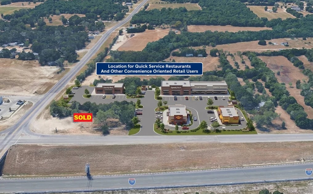
active ListedSouthwest Corner of I-14 and FM 1670 Belton, Texas
Asking price
$12
Lot
154,333 sqft

Overview
- Ideal Location for Quick Service Restaurants And Other Convenience Oriented Retail Users
- The subject property is currently deed restricted against future use as a convenience store, gasoline station, and certain other uses.
- The subject property is currently zoned Retail by the City of Belton
Lot 1: 3.543 Acres (154,333 Sq. ft.) Potentially may be re-subdivided into two or more smaller lots to meet the needs of appropriate businesses Water: The City of Belton working with the Dog Ridge Water Supply Corporation is in the process of constructing a new 10 inch water line that will provide public water service and fire flow protection for future businesses on the subject property Sewer: The City of Belton is in the process of constructing a new 8 inch sewer line that will provide public sewer service for future businesses on the subject property Zoning: The subject property is currently zoned Retail by the City of Belton Cross Access Driveway Easements: Recorded Cross Access Driveway Easements are currently in place to provide access from all lots to future driveway cuts on both I-14 and FM 1670 Asking Price: $12.00 per sq. ft. Restrictions on future uses: The subject property is currently deed restricted against future use as a convenience store, gasoline station, and certain other uses. Lot 2: 1.078 Acres (46,938 Sq. ft.) was recently sold and is now owned by a different group, but potentially may be available for purchase by an appropriate non convenience store business
Documents
1 file- Land for Sale: I-14 and FM 1670, Belton, Texas Brochure · 4 pages · 661.7 KB , PDF, opens in a new tab
More Less
The brochure describes Lot 1, a 3.543-acre parcel at the southwest corner of I-14 and FM 1670 in Belton, offered at $12 per square foot and potentially divisible. The property is zoned Retail, with public water and sewer lines under construction and recorded cross-access easements; deed restrictions prohibit convenience stores, gasoline stations, and certain other uses. Lot 2, 1.078 acres, is stated to have been recently sold and may potentially be available from its new owner for an appropriate non-convenience-store business.
Summarized automatically from the document.
Property details
Utilities
- Fiber Internet
- No
Public record
County record
Researched Nov 12, 2026Tax lots
1 lot| Parcel number | Acres | Market |
|---|---|---|
| 5084451 | 1.078 | $95,324 |
Recorded sales
| Date | Document | Buyer |
|---|---|---|
| Oct 22, 20212 | 2021071086 | PREMIER BELTON TWO LLC |
Sources
- 1 stratmap land parcels 48 most recent · feature.geographic.texas.gov
- 2 Parcels · services5.arcgis.com
- 3 Planning · services5.arcgis.com
Figures as the county publishes them. Each source links to the page it was read from and, where the county published a document, to a copy kept on the day it was read.
Due diligence
 Find a commercial property inspector Book a certified commercial inspector in this area.
 Investment Property Analyzer Run the numbers on this property before you offer. Free.
From our partner CCPIA — the Certified Commercial Property Inspectors Association
Location & area
Getting there
Straight-line distance- Highway exit
- I 14 / US 190 Exit 300 · 0.2 mi
- Freight rail
- BNSF Lampasas Subdivision · 2.3 mi
- Airport
- Draughon-Miller Central Texas Municipal Airport (TPL) · 8.8 mi
- International airport
- Austin-Bergstrom International Airport (AUS) · 60.2 mi
Within a mile: 0 restaurants · 1 shops · 0 grocery stores · 1 schools · 0 parks
Distances and places from © OpenStreetMap contributors.
Demographics
U.S. Census ACS · 2019–2023 · LEHD| Statistic | 1 mi | 3 mi | 5 mi |
|---|---|---|---|
| Population | 1,909 | 19,250 | 38,438 |
| Jobs (people working here) | 1,042 | 9,534 | 14,013 |
| Daytime population (est.) | 2,268 | 21,429 | 37,042 |
| Median household income | $54,603 | $75,803 | $76,608 |
Household income
Share of households · 1 mi- Under $25k
- 14%
- 101
- $25k–$50k
- 31%
- 221
- $50k–$100k
- 25%
- 172
- $100k–$200k
- 27%
- 187
- $200k+
- 3%
- 21
Population by age
Share of residents · 1 mi- Under 18
- 29%
- 556
- 18–24
- 4%
- 69
- 25–34
- 15%
- 281
- 35–44
- 18%
- 340
- 45–54
- 6%
- 110
- 55–64
- 14%
- 275
- 65–74
- 10%
- 193
- 75+
- 4%
- 85
Housing
Share of housing units · 1 mi- Owner occupied
- 53%
- 389
- Renter occupied
- 43%
- 313
- Vacant
- 4%
- 30
Median income by age
Age of householder · 1 mi- 25–44
- $89,950
- 45–64
- $66,315
- 65+
- $35,577
Jobs by industry
Share of jobs · 1 mi- Retail, food & lodging
- 4%
- 38
- Health care
- 5%
- 54
- Education
- 0%
- 0
- Professional & finance
- 38%
- 391
- Construction & manufacturing
- 41%
- 426
- Wholesale & logistics
- 10%
- 108
- Government
- 0%
- 0
- Other services
- 2%
- 25
Education
Share of adults 25+ · 1 mi- No HS diploma
- 20%
- 252
- High school
- 24%
- 305
- Some college
- 22%
- 278
- Bachelor's
- 25%
- 323
- Graduate
- 10%
- 126
Race & ethnicity
Share of residents · 1 mi- White
- 67%
- 1,277
- Black or African American
- 2%
- 45
- Asian
- 0%
- 0
- Two or more races
- 21%
- 396
- Other
- 10%
- 191
Hispanic or Latino, of any race 30%
Natural hazard risk
FEMA National Risk Index · December 2025- Overall
- Moderate
- Tornado
- Very High
- Hail
- High
- Lightning
- High
- Cold wave
- High
- Winter weather
- High
- Flooding (inland)
- Moderate
- Wildfire
- Moderate
- Strong wind
- Moderate
- Heat wave
- Moderate
- Hurricane
- Low
- Ice storm
- Low
- Landslide
- Low
- Drought
- Very Low
- Earthquake
- Very Low
Ratings are for the census tract, relative to all U.S. tracts — not a parcel-level model.
- EPA-Tracked Facilities Within 1 Mile
- 88
- Toxic-Release Facilities Within 1 Mile
- 0
- EPA Severe Violators Within 1 Mile
- 0
- Open Leaking-Tank Cases Within ½ Mile
- 0
- Leaking-Tank Releases Within ½ Mile
- 0
- Underground Tank Sites Within ¼ Mile
- 1
Location & Zoning
- Opportunity Zone
- No
Public data for 3657 West US Highway 190 Service Road — the building's own page, which stays up after this listing closes.