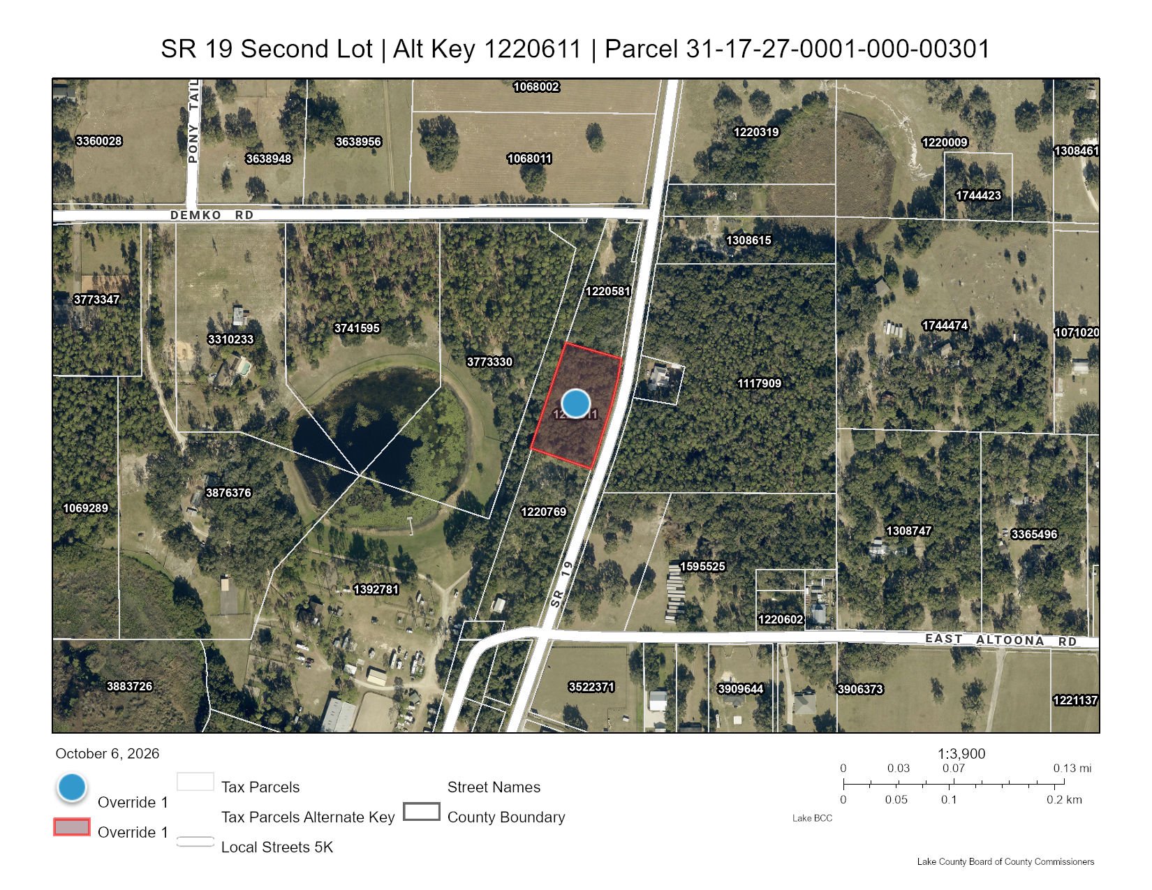
Land for sale
active ListedLand for Sale in Altoona, FL
Asking price
$215,000
Lot
1.5 ac
Overview
- Approximately 1.5-acre commercial lot zoned C-2
- On State Road 19, immediately south of the SR 19/Demko Road corner parcel
- Well shaft and old garage shell on the property
- The adjacent SR 19/Demko Road corner parcel is NOT included
- Lake County parcel 31-17-27-0001-000-00301 (Alternate Key 1220611)
Altoona, Lake County, Florida — FOR SALE BY OWNER. Approximately 1.5-acre commercial lot on State Road 19 near Demko Road, zoned C-2. Asking $215,000. A well shaft and an old garage shell are on the property. This is the parcel immediately south of the SR 19/Demko Road corner parcel; the adjacent corner parcel is NOT included. Buyer to verify zoning, permitted uses, access, utilities, dimensions and development requirements.
Due diligence
 Find a commercial property inspector Book a certified commercial inspector in this area.
 Investment Property Analyzer Run the numbers on this property before you offer. Free.
From our partner CCPIA — the Certified Commercial Property Inspectors Association
Location & area
Getting there
Straight-line distance- International airport
- Leesburg International Airport (LEE) · 14.3 mi
Distances and places from © OpenStreetMap contributors.
Demographics
U.S. Census ACS · LEHD| Statistic | 3 mi | 5 mi |
|---|---|---|
| Population | 1,795 | 8,179 |
| Jobs (people working here) | 201 | 1,441 |
| Daytime population (est.) | 1,318 | 5,444 |
| Median household income | $64,055 | $71,130 |
Household income
Share of households · 3 mi- Under $25k
- 21%
- 172
- $25k–$50k
- 21%
- 168
- $50k–$100k
- 30%
- 242
- $100k–$200k
- 19%
- 156
- $200k+
- 10%
- 79
Population by age
Share of residents · 3 mi- Under 18
- 11%
- 203
- 18–24
- 8%
- 142
- 25–34
- 8%
- 149
- 35–44
- 3%
- 61
- 45–54
- 10%
- 184
- 55–64
- 15%
- 268
- 65–74
- 11%
- 205
- 75+
- 32%
- 583
Housing
Share of housing units · 3 mi- Owner occupied
- 35%
- 349
- Renter occupied
- 47%
- 468
- Vacant
- 18%
- 179
Median income by age
Age of householder · 3 mi- 25–44
- $64,500
- 45–64
- $50,476
- 65+
- $73,976
Jobs by industry
Share of jobs · 3 mi- Retail, food & lodging
- 18%
- 37
- Health care
- 2%
- 4
- Education
- 24%
- 49
- Professional & finance
- 1%
- 3
- Construction & manufacturing
- 17%
- 35
- Wholesale & logistics
- 30%
- 60
- Government
- 3%
- 6
- Other services
- 3%
- 7
Education
Share of adults 25+ · 3 mi- No HS diploma
- 8%
- 122
- High school
- 31%
- 456
- Some college
- 32%
- 467
- Bachelor's
- 17%
- 242
- Graduate
- 11%
- 163
Race & ethnicity
Share of residents · 3 mi- White
- 89%
- 1,596
- Black or African American
- 5%
- 89
- Asian
- 0%
- 0
- Two or more races
- 4%
- 80
- Other
- 2%
- 30
Hispanic or Latino, of any race 6%
Natural hazard risk
FEMA National Risk Index · December 2025- Overall
- Low
- Wildfire
- Moderate
- Hurricane
- Moderate
- Tornado
- Moderate
- Strong wind
- Moderate
- Lightning
- Moderate
- Flooding (inland)
- Low
- Cold wave
- Low
- Hail
- Very Low
- Heat wave
- Very Low
- Drought
- Very Low
- Earthquake
- Very Low
- Landslide
- Very Low
Ratings are for the census tract, relative to all U.S. tracts — not a parcel-level model.
- EPA-Tracked Facilities Within 1 Mile
- 10
- Toxic-Release Facilities Within 1 Mile
- 0
- EPA Severe Violators Within 1 Mile
- 0
- Open Leaking-Tank Cases Within ½ Mile
- 0
- Leaking-Tank Releases Within ½ Mile
- 0
- Underground Tank Sites Within ¼ Mile
- 0
Location & Zoning
- Zoning
- C-2
- Opportunity Zone
- No
Public data for State Road 19 — the building's own page, which stays up after this listing closes.